8/19/2003: Night sky during blackout

Undertoad • Aug 19, 2003 12:19 pm
Image

The wire services carried a version of this, but I felt it was weak. This version was sent along by Elspode. It's from space.com.

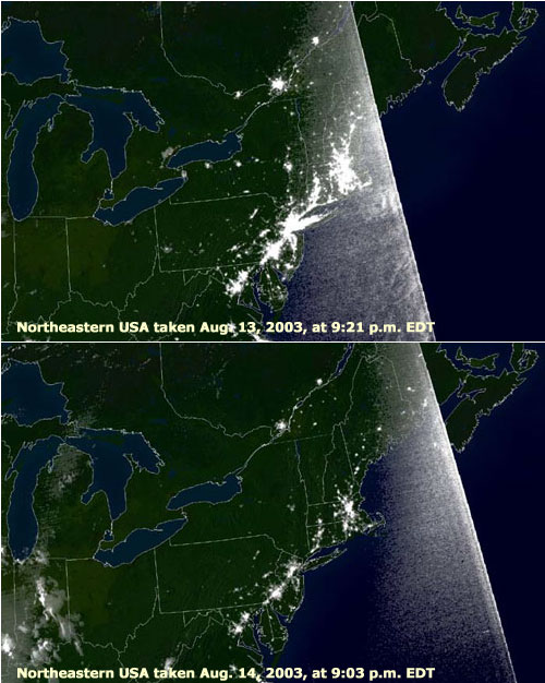
In particular, the wire services didn't carry the time information. So there was no explanation for why unaffected areas like Boston, Philly, Baltimore and D.C. are less lit up. 9:03 PM is pretty much dusk at this time of year, so fewer lights are on, and none in locations west where it's still day.

It's a good one for the record and especially since IotD has been a big fan of all the night sky images.
dave • Aug 19, 2003 12:28 pm
I think the best state to look at is New York. Compare the island on both days. Almost the entire state is dark on the 14th.

Very good pair of images.
CubHoek • Aug 19, 2003 12:44 pm
What is the white line on the right?
Undertoad • Aug 19, 2003 12:52 pm
In trying to find out what the line is, I found this page

http://www.noaanews.noaa.gov/stories/s2015.htm

...which is the actual source of the images above. There are some much higher-resolution images there. But no explanation of the line.
juju • Aug 19, 2003 1:10 pm
Looks like one of those circular radar-sweep thingies you see in movies.
SteveDallas • Aug 19, 2003 1:10 pm
My first instinct was that the white line would be the terminator (the division between night & day), but it's not positioned correctly. The 9:03 image shows MORE on the "night" side rather than less.
LUVBUGZ • Aug 19, 2003 3:35 pm
Goes to show what an educated idiot I am, but I thought the line was the edge of earth, ya know it being flat and all:p

It actually looks like that radar thingie juju mentioned, I'm sure they exist outside the movie industry. Anyway, I concur w/ my new hetero friend.
juju • Aug 19, 2003 3:50 pm
On the other hand, if it is a radar-sweep thingie, it's moving in the direction of its trail.
xoxoxoBruce • Aug 19, 2003 3:57 pm
Both radar and sonar have those sweep lines but that looks like a shutter curtain from a camera. I doubt if they use a regular camera, more likely an array of light receptors like a digital camera. The receptors are probably very sensitive and have to be shuttered to prevent streaking. But I'm only guessing :rolleyes:
xoxoxoBruce • Aug 19, 2003 3:59 pm
No, Juju. It's a day apart.
LUVBUGZ • Aug 19, 2003 4:24 pm
Originally posted by xoxoxoBruce
No, Juju. It's a day apart.


Once again, I must concur, this time w/Bruce. The sweepie thingie is moving counter-clockwise. These photos were take a day apart, it just so happened that on the 14th the thingie was east of (to the right of, further counter-clockwise from, etc.--take your pick, you know what I'm trying to say:rolleyes: ) its location on the 13th. I actually don't have a clue to what it is, but the sweepie sounds good as it appears to be radiating out from a central point while moving in a counter-clockwise fashion.:confused:
ndetroit • Aug 19, 2003 4:32 pm
maybe it was raining in outer space when they took these pictures and it's the windshield wiper on the shuttle?

...
juju • Aug 19, 2003 5:01 pm
Ohh, I get it! I only looked at the time. :)
MaggieL • Aug 19, 2003 5:22 pm
I suspect the "white line" is in fact the edge of the image as received from the satellite. The costal outlines and poltical borders are supplied by another ground based image on which the satellite image is superimposed. Notice nothing other than the background map image is displayed on the other side of the line.
Pie • Aug 19, 2003 5:25 pm
Originally posted by MaggieL
The costal outlines and poltical borders are supplied by another ground based image on which the satellite image is superimposed.


...You mean the US doesn't have state boundaries neatly marked with glow-in-the-dark paint? Darn.


- Pie
xoxoxoBruce • Aug 19, 2003 5:28 pm
Mag, so you think the cities along the Nova Scotia coast are part of the Geo-Political overlay rather than the space image?
gossard187 • Aug 19, 2003 9:56 pm
the white line is the edge of the field of view for that camera. the slope of the line shows the track of the satellite. Anyways, you can see the same thing on the evening news weather report, look at the rain data for the whole country. you can faintly see where theres a line just off the east coast and through the midwest. these are where they overlap two satellite images and can't perfectly match gain. why is that edge so bright? bad pixels on the ccd? shutter effect? Maybe they use a one piece shutter and that side is exposed the longest?
Elspode • Aug 19, 2003 11:37 pm
If you go to the site UT posted, and look at the very large, hi-rez versions of the pics, you will clearly see that the white edge in the pics is indeed the Eastern extent of the image, with the rest of the background being the geopolitical overlay. It shows up much better in the hi-rez versions of these same pictures.

They also have some annotated before and after shots that are kind of neat.
MaggieL • Aug 22, 2003 12:43 pm
Originally posted by xoxoxoBruce
Mag, so you think the cities along the Nova Scotia coast are part of the Geo-Political overlay rather than the space image?

Yes....those white spots aren't cities, they're just places where the map has drawn a lot of near-fractal "krinkly bits" (term coined by Slarty Bartfast) following small inlets, coves and islands along the shoreline. Since they're all white, it appears to make "cities".
xoxoxoBruce • Aug 22, 2003 3:02 pm
Another one.:)
juju • Aug 22, 2003 3:07 pm
Where are all the clouds?
LUVBUGZ • Aug 22, 2003 3:22 pm
Originally posted by juju
Where are all the clouds?

In your mind, juju:p
xoxoxoBruce • Aug 22, 2003 7:41 pm
Originally posted by juju
Where are all the clouds?
You question the Gumint? You fool!:D
juju • Aug 23, 2003 12:06 am
I just think it's interesting how the entirety of the United States was completly cloudless at exactly 23:15 Eastern time on August 14th.

Heh heh. :)
MaggieL • Aug 23, 2003 12:40 am
Originally posted by juju
I just think it's interesting how the entirety of the United States was completly cloudless at exactly 23:15 Eastern time on August 14th.

As I recall, it was a very nice day...I was up flying just before the outage, because it was the first clear day in what seemed like weeks.

Be that as it may, I think someone needs to review his knowlege of US geography before he Photoshops. That patch of RGB(0,0,0) (the one that doesn't match any of the other dark areas in the image) blobbed out over a much bigger area than the blackout did.
xoxoxoBruce • Aug 23, 2003 12:40 am
Remember that! Not even the clouds can protect you from W.:rolleyes:
gossard187 • Aug 23, 2003 5:47 pm
Originally posted by xoxoxoBruce
Another one.:)


With the "blackout" area being so black, it looks more like a giant flood (that somehow covered the appalachians?) since thats the color of the water, not the dark ground...
CharlieG • Aug 25, 2003 8:42 am
Originally posted by xoxoxoBruce
Another one.:)


Hoax, check snopes
xoxoxoBruce • Aug 25, 2003 6:16 pm
Party pooper.:p I had 'em going.:D