5/11/2003: Shenandoah topography

Undertoad • May 11, 2003 12:23 pm
Image

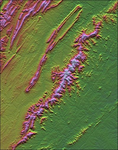
The Earth Sci pic of the day yields this nice one of Virginia's Shenandoah national park by Shuttle Radar Topography Mission data.

Now here's the odd part: no camera was used to create this image.

They recorded the various elevations in detail, via radar on the shuttle. Then they created this image from that data: one pass to create the shading (which areas are light and which dark) and one to create the color (different heights of the land get different colors).
xoxoxoBruce • May 11, 2003 2:20 pm
I can see how they can assign colors to elevations but I don't understand the shading part.
Undertoad • May 11, 2003 2:34 pm
I think they go North to South, and when there is drop in elevation they add darkness (with more darkness for a larger drop) so you get a shadowing effect. Or something.
wolf • May 11, 2003 5:54 pm
I'd love to see images like this next to a topographic map of the same area ... I'm guessing that between that pink ridgy thing and the pink hilly thing is a river ... and those squiggles up toward the top also look like a watercourse. (of course it could be a highway of extreme width and constant declination from the landsurface, but ...

NEAT stuff UT!
xoxoxoBruce • May 11, 2003 8:01 pm
About 20% of the way down the mountain ridge on the right it cleaves. I think that's the junction of the Skyline Drive and Blueridge Parkway. I remember one summer night at a scenic pulloff near there, on the hood of a black Thunderbird, with a full moon.....
Griff • May 11, 2003 8:22 pm
with a full moon to guide him Gen. Thomas "Stonewall" Jackson once again repulsed the Yankee invader.