Mar 13, 2010: Inuit Map

xoxoxoBruce • Mar 13, 2010 12:26 am
Inuit Wood Map, to be more precise, from Kalaallit Nunaat... that's Greenland to most of us.

Image

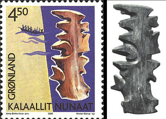
Not exactly a AAA TripTik, and a far cry from Google maps, although still a cut above MapQuest.
It doesn't look very detailed, does it, well, there's a reason for that...
These Inuit charts were usually carved from driftwood and are made to be felt rather than looked at. The Inuit hold this map under their mittens and feel the contours with their fingers to discern patterns in the coastline. The land is very abstract. It is limited to “edges” that can be felt on a dark night in a kayak. Since they are made of wood they are impervious to the weather, and will float if they are dropped overboard accidentally. It will also last longer that one that is printed.

See, practical, functional, and close enough in detail. :thumb:

link
SPUCK • Mar 13, 2010 6:42 am
Heep good cook fire...


I cannot find the map Dribbling Reindeer.
Griff • Mar 13, 2010 8:19 am
Little Pete just juxtapositioned this with the doofus who blew up his hand in the weapons thread. "Humans can be smart too... of course they lived a long time ago..."
newtimer • Mar 13, 2010 9:21 am
"It's no wonder we're lost, dear. You're holding the map upside down in your mitten!"
"Don't yell at me. Just paddle over there and ask that polar bear for directions."
xoxoxoBruce • Mar 13, 2010 9:36 am
Bah, real Inuits don't ask for no stinkin' directions. :headshake
glatt • Mar 13, 2010 10:55 am
I'd love to see a comparison of this set against a modern map of the same coastline.
xoxoxoBruce • Mar 13, 2010 12:27 pm
Don't forget, none of these people saw more of Greenland at once, than they could see from a tall hill, and probably most never saw all of the coast in their lifetimes.
glatt • Mar 13, 2010 1:28 pm
Sure, but the same can be said of the maps from Columbus's time, and they are cool to look at and compare with modern maps.
squirell nutkin • Mar 13, 2010 4:11 pm
glatt;640636 wrote:
I'd love to see a comparison of this set against a modern map of the same coastline.


I think it is one of these two coastlines, and I suspect there is a flexible resolution and scale to the carved map, and it must be a custom made map that might exclude certain features or landmarks that may be obvious to the maker.
ZenGum • Mar 13, 2010 5:39 pm
xoxoxoBruce;640621 wrote:
Bah, real Inuits don't ask for no stinkin' directions. :headshake


That's right. The males know the way; the females rely on women's Inuition.
squirell nutkin • Mar 13, 2010 7:24 pm
Despite being halfway around the world, Zen, you are still able to deliver punishing blows.
Gravdigr • Mar 15, 2010 2:03 pm
ZenGum;640672 wrote:
That's right. The males know the way; the females rely on women's Inuition.


100 points.:D
glatt • Mar 17, 2010 1:52 pm
I was browsing through old Popular Science magazines online and came across something similar from 1933.