We be ler'n more 'bout 'Canes
Tropical storms for this year are:
Andrea Barry Chantal Dean Erin Felix
Gabrielle Humberto Ingrid Jerry Karen
Lorenzo Melissa Noel Olga Pablo
Rebekah Sebastien Tanya Van Wendy
Quietly moving up the east coast is the second Atlantic tropical storm of the year - Barry. In the Pacific and ongoing is Barbara - also a second tropical storm.
Projection for Barry from the National Hurricane Center:
Thank GOD! Finally some rain. I we could just it to stall out over the coast for about a week we would be good to go.
It's the chav/trailer-park naming theme then, this year?
The should go for the wuss theme. Can you imagine being pummeled by a storm called Arielle, Barnaby, Clarissa, Dillon ... Jervais ... Mortimer ...
i have a sincere sense of foreboding about Olga.
Imagine that, a storm named.... Wendy
The thread title threw me off a little. I expected a big lecture from tw about our lack of understanding of how hurricane seasons vary from year to year. Just heard on NPR the other day that while there is some correlation with average Atlantic temperature, it doesn't match that closely. A better match is the el Nino/la Nina cycle. Got no links for you, as it was just a report on the radio.
Ya, I recently sat through part of a NASA presentation that gave the impression that water temperature was the main factor, but I think you're right about el Nino. They do have some neat tech developing to predict rainfall by looking inside a hurricane now, cool stuff.
Each year tw takes more letters out of his hurricane thread titles. A few more and we'll be looking at something like
B Lrn Mo Canz
Chantal will play nice, but she'll cut you if you cross her.
Here's 150 years of storms.
And that concentration of Force Five tracks in WestPac correlates with the wellspring of El Nin~o sea current flows, doesn't it?
We wouldn't mind a bit of el fucking nino down this way thankyou very bloody much!
Yeah, the paucity of big-ole-rainy-storm tracks through your latitudes does illustrate that dryness problem in a big way. Anyone have an idea why such hemispheric asymmetry?
There is a lot of talk about el nino, but I don't know if that's true or not. I think we just need rain and there isn't any.
And that concentration of Force Five tracks in WestPac correlates with the wellspring of El Nin~o sea current flows, doesn't it?
Don't know, but that is a record of the last 150 years.
Imagine that, a storm named.... Wendy
I've never yet come a cross a wimpy Wendy. They should have gone for Willow
Awesome image, btw, xoB, thanks.
I think we just need rain and there isn't any.
Notice how dry Australia is. Every time a hurricane hit the coast, Australia just sucks that tropical storm right up. American 'canes often may go 1000 miles inland. Rarely does that happen in Australia.
We get cyclones. They're no where near the size of hurricanes tw. That would explain their limited lifespan once they hit the coast.
A third tropical storm - Chantal - has finally formed off of NE United States. Unusual is for a storm to form this far north. More unusual is its projected course - just south of Greenland and by Friday approaching Iceland. Predicted track shown below.
However that is not the significant event this week. Like last year, storms from Africa crossed the Atlantic, stayed below 10 degrees N latitude, and did not veer north until arriving in Panama or Eastern Pacific. Well the Pacific already has its five tropical storm. One even threatened the big island of Hawaii.
This week, that storm track moved north. A potential storm was forming just north of Brazil (rather than crossing Brazil). If this trend continues as predicted, the 2007 Hurricane race has just begun.
An excerpt from satellite images of 31 July shows storm tracks from Africa (right) and curving northward across the Atlantic towards Cuba (left). Some storms in the old track across northern South America and Costa Rica are still observed.
Hurricane Dean is expected to be approaching Puerto Rico on Saturday. Assuming it continues this same curving path, Dean should arrive somewhere between northern FL and the US east coast. This storm has been developing so early since leaving Africa as to be worth significant attention. It will probably skim up the east coast - remain at sea. But we really will not know until maybe the 20th of Aug.
Start looking for sales on hurricane party goods. Mid Atlantic US residents have not had a good reason for a hurricane party in a long time. If you invite Erin, Felix, Gabrielle or Ingrid, they might have such a good time as to return. Select your guest list with care.
I hope it stays about 50 to 100 miles offshoe and tears up the hot water thats been out there for 2 moths - Thats just what the fishin needs!
personally, a cat 1 or 2 is perfect. couple days off work, paid... hurricane parties... an impromptu boozefest is always fun.
Assuming it continues this same curving path, Dean should arrive somewhere between northern FL and the US east coast.
The models have shifted to the south each time they've run them, today. That low that was supposed to pull it north and keep it in the Atlantic might not be low enough to do so.
Ah, Dean, please don't go into the gulf.

Ah, Dean, please don't go into the gulf.
While busy looking east at Dean, Kitsume forget to look over his right shoulder. A potential Tropical Storm already playing hide and go seek ... in the Gulf:
Chantal will play nice, but she'll cut you if you cross her.
Here's 150 years of storms.
A little late, but note how Taiwan is smack-dab in the center of the roughest track...
A Tropical Storm watch has in fact been issued for coastal Texas.
While busy looking east at Dean, Kitsume forget to look over his right shoulder. A potential Tropical Storm already playing hide and go seek ... in the Gulf:
Possibly Erin out there, but we're hopefully only looking at a tropical storm on landfall. Although, I don't think Texas needs any more rain?
Would have been helpful if the system had gone to the parched AL/MS area.
So maybe it will sink NO this time for good.
None of the Dean models seem to say anything about it heading up the east coast.
http://intellicast.com/Storm/Hurricane/Active.aspx?storm=2&type=trackHurricane Felix was not even a depression until it arrived a few hundred miles east of the Windward Antilles. Behind it is another cyclonic action that could become something 'tropical' once it arrives in the same warm water.
Storms that roll off Africa encounter water that is at New Jersey ocean temperatures. These storms attract no attention until warmer water is found. Warmer water of the Caribbean has created some hurricanes such as Dean - a category 5. But most storms have still continued across Central America to create eight tropical storms and eleven tropical depressions. One even threatened Hawaii.
Unlike 2005, Atlantic water has been cooler. Even the Caribbean and Gulf have been cooler. Current storm track does not even threaten anything north of Cuba. Felix will probably cross Mexico's Yucatan peninsula. Next mid-Atlantic storm is following and probably will be ignored until it also finds the same warm water that energized Felix.
Wow. Only two days ago it was not even a tropical despression. Now Felix is a category five hurricane.
Here's a picture of the hurricane Felix eyewall, at night, by moonlight. It was taken from a plane flown by the Hurricane Hunters at Keesler AFB, MS.
Wunderground has another picture of the eyewall and pictures of the radar. It mentions it was a rough flight and the NOAA plane also took a beating at the Northeast eyewall.
It has been as if God suddenly puts up a wall to protect Florida, or hates northen Georgia. Whereas tropical storms might be five in a season, we now have the fourteenth - tropical storm Noel. Western Atlantic tropical depression has experienced 20 tropical depressions. Eastern Pacific, where most of the potential tropical storms when to, had about as many. Most storms pass over or just north of South America, or veered off like a retired Englishman visiting his home country.
Noel did not get the National Hurricane Center's attention until yesterday when it was just east of the Dominican Republic and was not predicted to intensify. Latest prediction is that Noel will bounce off that invisible Florida wall and head for Bermuda.
http://www.coaps.fsu.edu/~maue/tropical/
Where is all the talk about Golbal Warming and the new age of super storms?
http://www.coaps.fsu.edu/~maue/tropical/
Were is all the talk about Golbal Warming and the new age of super storms?
Oh, yeah, I'm extremely thankful a partial season worth of data was able to prove the entire theory of stronger storms being produced by warmer SSTs to be wrong. I was getting worried, what with it being the only year for two category fives to make landfall in recorded history.
Pardon me while I relax and move even closer to the coast.
I live 5 miles from open ocean. :D
I live 5 miles from open ocean. :D
Noooo... you have me beat me by one mile!
One mile makes a difference, right? :unsure:
Imagine that, a storm named.... Wendy
And Windy has stormy eyes
That flash of the sound of lies
And Windy has wings to fly
Above the clouds
Noooo... you have me beat me by one mile!
Which is better? One mile closer or one mile farther inland?
Which is better? One mile closer or one mile farther inland?
The correct answer is: "Ohio"
lNoel is an overachiever. He became a hurricane tonight. He may even skirt closer to Cape Cod. A November hurricane in another season that has seen something we rarely ever saw category five hurricanes - and multiple.
This year, even Shanghai was threatened by a massive hurricane that fortunately verged off by something like 100 miles. That would have been equivalent to a category four striking NYC. There are no plans for hurricanes of that size striking the American mid east coast. Its just not suppose to happen.
Noel may be the end of this thread. Nobody expects hurricanes in November. It just never happened. And more than one category five in a decade? Almost unheard of.
God's hurricane wall around FL appears to have worked this year.
at least noel provided some late season and much needed rains. we're still on water restrictions here.
Apparently god loves to tease N and W Georgia, Tennessee, and central North Carolina. Put what they need a few hundred miles away. Hold Noel out there like a carrot on a stick. Bad Noel. Is there ever a good hurricane?
at least noel provided some late season and much needed rains. we're still on water restrictions here.
And for a Cat 1 has killed some 115 people.
And for a Cat 1 has killed some 115 people.
let me play devil's advocate for a minute...
what do you think is going to happen when you cut down 99% (literally) of the vegetation on an island in the middle of the caribbean?
I'm not saying that those people deserve to die - not at all. I know I'm lucky in this life, and my heart goes out to all of those who are less fortunate. I'm just saying, it's expected that any kind of tropical system - even the weakest tropical storm
will cause loss of life in those island nations. And some of it, sadly, is their own fault.
And for a Cat 1 has killed some 115 people.
Noel was only a tropical depression; not even a tropical storm - when it rained on Haiti and the Dominican Republic.
Global and Northern Hemisphere Tropical Cyclone Activity [still] lowest in 30-years
Tropical cyclone (TC) activity worldwide has completely and utterly collapsed during the past 2 to 3 years with TC energy levels sinking to levels not seen since the late 1970s. This should not be a surprise to scientists since the natural variability in climate dominates any detectable or perceived global warming impact when it comes to measuring yearly integrated tropical cyclone activity. With the continuation (persistence) of colder Pacific tropical sea-surface temperatures associated with the effects of La Nina, the upcoming 2009 Atlantic hurricane season should be above average, as we saw in 2008. Nevertheless, since the Atlantic only makes up 10-15% of overall global TC activity each year (climatological average during the past 30 years), continued Northern Hemispheric and global TC inactivity as a whole likely will continue.
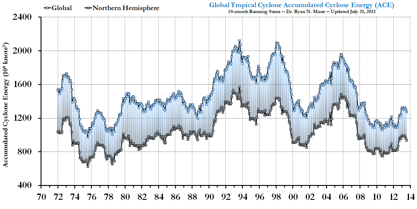
Why the record low ACE?
During the past 2 years +, the Earth's climate has cooled under the effects of a dramatic La Nina episode. The Pacific Ocean basin typically sees much weaker hurricanes that indeed have shorter lifecycles and therefore -- less ACE . Conversely, due to well-researched upper-atmospheric flow (e.g. vertical shear) configurations favorable to Atlantic hurricane development and intensification, La Nina falls tend to favor very active seasons in the Atlantic (word of warning for 2009). This offsetting relationship, high in the Atlantic and low in the Pacific, is a topic of discussion in my GRL paper, which will be a separate topic in a future posting. Thus, the Western North Pacific (typhoons) tropical activity was well below normal in 2007 and 2008 (see table). Same for the Eastern North Pacific. The Southern Hemisphere, which includes the southern Indian Ocean from the coast of Mozambique across Madagascar to the coast of Australia, into the South Pacific and Coral Sea, saw below normal activity as well in 2008. Through March 12, 2009, the Southern Hemisphere ACE is about half of what's expected in a normal year, with a multitude of very weak, short-lived hurricanes. All of these numbers tell a very simple story: just as there are active periods of hurricane activity around the globe, there are inactive periods, and we are currently experiencing one of the most impressive inactive periods, now for almost 3 years.

Bottom Line
Under global warming scenarios, hurricane intensity is expected to increase (on the order of a few percent), but MANY questions remain as to how much, where, and when. This science is very far from settled. Indeed, Al Gore has dropped the related slide in his PowerPoint (btw, is he addicted to the Teleprompter as well?) Many papers have suggested that these changes are already occurring especially in the strongest of hurricanes, e.g. this and that and here, due to warming sea-surface temperatures (the methodology and data issues with each of these papers has been discussed here at CA, and will be even more in the coming months). The notion that the overall global hurricane energy or ACE has collapsed does not contradict the above papers but provides an additional, perhaps less publicized piece of the puzzle. Indeed, the very strong interannual variability of global hurricane ACE (energy) highly correlated to ENSO, suggests that the role of tropical cyclones in climate is modulated very strongly by the big movers and shakers in large-scale, global climate. The perceptible (and perhaps measurable) impact of global warming on hurricanes in today's climate is arguably a pittance compared to the reorganization and modulation of hurricane formation locations and preferred tracks/intensification corridors dominated by ENSO (and other natural climate factors). Moreover, our understanding of the complicated role of hurricanes with and role in climate is nebulous to be charitable. We must increase our understanding of the current climate's hurricane activity.
A very interesting read. Some of which is above me. I highly recommend it still. There are some really smart people here and I'd love your/their take on it.
(Sorry the photos are so large If a mod could reduce that'd be great)
I don't know much about weather but storms are a function of thermodynamic energy which is fueled by temperature differentials in close proximity which, in turn, is created by ocean currents moving warm/cold water towards each other. So either the currents are slowing down or the temperature differential at each end of the current is shrinking - or some of each.
I also checked the peaks of the first graph against the 11-year sunspot cycle.
No corellation. Just wondering.
It might be worth checking this out against undersea volcanic and tectonic activity as well.