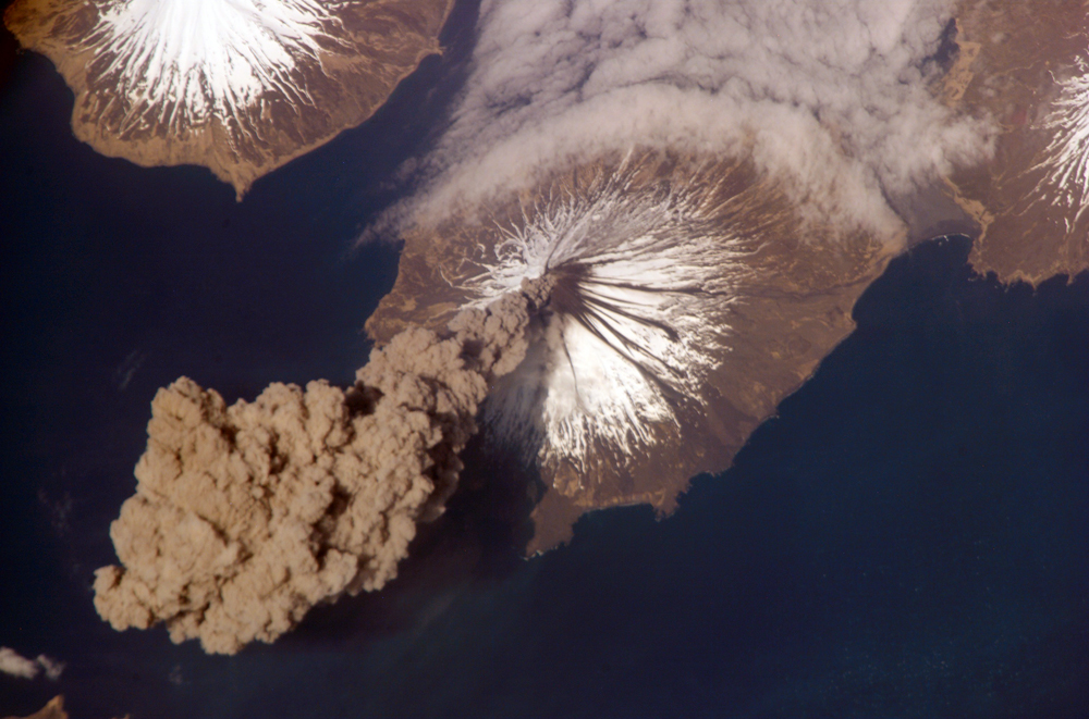
I do in fact have more queue here! This is the Cleveland Volcano, photographed from the ISS
and detailed by NASA
here.
This image, acquired shortly after the beginning of the eruption, captures the ash plume
moving west-southwest from the summit vent. The eruption was short-lived; the plume
had completely detached from the volcano summit two hours later. Ash plumes from
Cleveland Volcano have reached heights of 12 kilometers and can present a hazard to
trans-Atlantic jet flights. The fog bank visible at image top center is a common feature
of the Aleutian volcanoes. Cleveland Volcano, situated on the western half of
Chuginadak Island, is one of the most active of the volcanoes in the Aleutian Island
chain extending west-southwest from the Alaska mainland.

This is another image of "cloud streets", which
IotD first documented here.
Alaska has the biggest everything......even zits.;)
This make me wonder what happened to my friend who said he wanted to go to Alaska after grad.
I'd like to see a broader view because all three islands are volcanoes, judging from the shape and snow pattern.
This make me wonder what happened to my friend who said he wanted to go to Alaska after grad.
Probably swept into the ocean by a giant lahar...
The Cleveland Volcano would be an excellent name for a sports team, or a bar.
And they say they don't make any new land.
Okay, this is weird, but at first glance, seeing just the top of the image, these looked like mushrooms to me . . . but that was pre-tea . . .
Thanks for the images Bruce! The volcanoes look wonderful. It looks like Herbert had a big explosion with a lovely large crater as evidence. Now I want to fly over the Aleutians on a clear day.
Hey, CaMama! What part of the Left Coast are you in, anyway? I'm a native Californian (although I moved away when I was three...).
There's a steam plume coming off of Mt Cleveland in Bruce's pic, too. Cool.
Ash plumes from Cleveland Volcano have reached heights of 12 kilometers and can present a hazard to trans-Atlantic jet flights.
Should that be trans-Pacific?
hmm... maybe trans continental? prevailing winds blah blah...
How about Great Circles? The navigation routes - shortest distance between 2 points - are figured on great circles, but I don't have a globe handy to figure them out.