4/20/2006: San Andreas Fault marked by fence movement

Undertoad • Apr 20, 2006 2:46 pm
Image

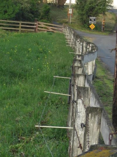
Excuse me for forgetting my notes on this one, I think it was an Earth sci pic of the day. In this case, this fence was straight when it was built, but since then shows the efforts of the Fault. And here is where the resident residents can give far better information than I can. All I remember is my Earth Science teacher, in 9th grade, explaining that California was not actually going to fall into the ocean, and that more likely eventually western LA was going to be next to eastern SF.

I now realize that was hyperbole, but in the above shot you can actually see how the shifting affected this land; one side of it shifted one way while the other shifted t'other, or maybe didn't shift at all.
Trilby • Apr 20, 2006 3:24 pm
Yeah, that would be my excuse. Some foreman would come along and tell me the fence I just built was crooked and I'd say it was San Andreas's fault.
Cochese • Apr 20, 2006 3:29 pm
Shouldn't the road be affected too?
glatt • Apr 20, 2006 3:46 pm
Maybe the road has been re-paved since the fence was built. The fence looks real old.
barefoot serpent • Apr 20, 2006 3:57 pm
The San Andreas Fault is an example of a right-lateral fault. That is, the slippage appears to move to the right looking across the fault line.

edit: historical photos of '06 SF Eathquake here:
http://quake.wr.usgs.gov/info/1906/historical.html
Elspode • Apr 20, 2006 5:06 pm
The April National Geographic has a piece about the San Francisco quake. In it, they have a picture of a fence that was originally constructed something like 75 years ago. Although it was rebuilt in the 1970's, according to the caption, it was rebuilt exactly as it was when it was torn down. Therefore, you see a displacement between sections of the fence of something like 15 feet...
Elspode • Apr 20, 2006 5:17 pm
...and here is the same fence, albeit not the same exact NG picture.
Wombat • Apr 20, 2006 7:05 pm
When I was at school there was a geography textbook with a great aerial shot of a long straight highway running through a desert. In the middle of the highway it did a sudden right-left turn where an eartquake had caused the land to slip sideways by about 20 metres. I've googled for this pic but unfortunately I can't find it.
xoxoxoBruce • Apr 20, 2006 7:59 pm
Here's the link. to the Earth Science story.
That was pretty funny, Brianna.:thumb:
xoxoxoBruce • Apr 20, 2006 8:06 pm
barefoot serpent wrote:
The San Andreas Fault is an example of a right-lateral fault.

Well duh, of course it is......it says so on the sign in the picture.


[SIZE="1"]I'm sorry, I couldn't resist. :D [/SIZE]
Kagen4o4 • Apr 20, 2006 9:24 pm
xoxoxoBruce wrote:
Well duh, of course it is......it says so on the sign in the picture.


[SIZE="1"]I'm sorry, I couldn't resist. :D [/SIZE]


nice

that seems to be my response to most of your posts
capnhowdy • Apr 20, 2006 10:17 pm
Very different setup on the electric fence than what I'm used to seeing.
skysidhe • Apr 20, 2006 10:30 pm
Prepare to be befuddled. :3_eyes:


Image
milkfish • Apr 20, 2006 10:56 pm
I like how someone posted a sign in the background of the picture so that Mother Nature would know what to do.
wolf • Apr 21, 2006 1:31 am
skysidhe wrote:
Prepare to be befuddled.


Simple. It runs straight across the equator.
floatingk • Apr 21, 2006 4:49 am
That reminds me of a place in Iowa where the mainstreet through town takes a right-lefter. This was due to a datum update or change and it turns ou the road perfectly follows a line of latitude. So as they were building it, they had to update it as well...
xoxoxoBruce • Apr 21, 2006 7:04 am
capnhowdy wrote:
Very different setup on the electric fence than what I'm used to seeing.
Yeah, the barbed wire nailed to the inside then the electric wire on standoffs means they seriously didn't want anything pushing on that fence. The fence in the background doesn't seem to be as well guarded so it must be the wiggle in this fence they're concerned with.
Maybe it's a tourist attraction. :right:
Kitsune • Apr 21, 2006 10:46 am
Brianna wrote:
I'd say it was San Andreas's fault.


We never would have had this problem if the hot coffee mod hadn't been released to the public.
barefoot serpent • Apr 21, 2006 10:55 am
Wombat wrote:
When I was at school there was a geography textbook with a great aerial shot of a long straight highway running through a desert. In the middle of the highway it did a sudden right-left turn where an eartquake had caused the land to slip sideways by about 20 metres. I've googled for this pic but unfortunately I can't find it.


Probably the Landers Earthquake (1992 California)
Image
form here: http://www.csun.edu/~vcgeo004/chapt15.htm
gen131 • Apr 21, 2006 12:14 pm
There is a fault line that crosses I-80 just west of Fairfield, California on the way to Vallejo. Every few years or so, they have to repave a couple yards of asphalt across the freeway, and repair the dividing wall as it breaks apart. My dad has commuted this stretch of 80 for over 20 years and I commuted it for 3, so we both have been able to see it. Sorry, no pictures tho. Maybe someone else has seen it?
BrianR • Apr 22, 2006 12:18 am
ME!