 11-25-2016, 07:38 PM
|
#1
|
|
The future is unwritten
Join Date: Oct 2002
Posts: 71,105
|
Nov 26th, 2016: Goodwin Sands
Quote:
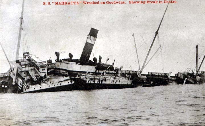
Six miles off the coast of Deal in East Kent, England, lies one of the most treacherous stretches of sand in Britain.
Lying in the middle of the English channel in the narrow Straits of Dover, close to one of the busiest shipping
channel in the world, the sands present a great challenge to navigators. Since the first documented shipwreck
on Goodwin Sands in 1298, more than 2,000 ships are believed to have wrecked here. Dozens of wrecks still lie
underneath the waves.
|
Quote:
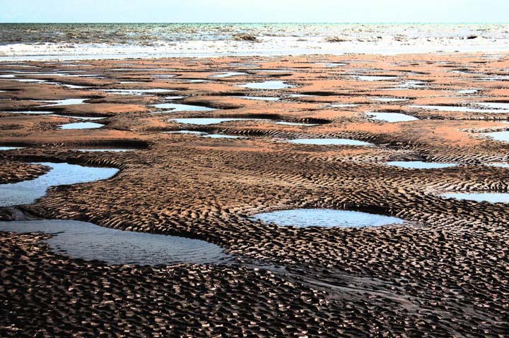
The Goodwin Sands is about 10 miles long and 3 miles wide at its widest, but because of the tides and currents,
the shoals are constantly shifting. Usually, the sand remains completely submerged between 8 to 15 meters
beneath the surface, but as the tide falls, the sandbank break the surface and expose about a tenth
of their total area. During these times, the sand is firm enough to walk upon.
Typically, a ship would run into the sand during rough weather and begin to break. Any survivor who manages
to escape onto the sand might have been able to light fires and attempt to attract the attention of passing ships,
or the Boatsmen of Deal and Kingsdown. If help didnt arrive within hours, the tide would return and the sand
would turn into quicksand, and ships and survivors would be engulfed.
|
Sounds like a good place for a youth hostel, no problem clearing out lingerers.
Quote:
Modern navigation technology, particularly that assisted by GPS, and detailed mapping of the channel now
allow ships to avoid the Goodwin Sands. There have been no major accidents here since a lightship capsized
in 1954 killing six crew members.
There is currently one lightship on the end of the sands to warn ships. The sands were once covered by
two lighthouses on the Kent mainland, one each covering the north and south ends of the sands. The South
Foreland lighthouse is now owned by the National Trust, and the North Foreland lighthouse is still in operation.
|
Modern navigation is much safer. The ocean is not.  link
link
__________________
The descent of man ~ Nixon, Friedman, Reagan, Trump.
|

|

|


 Threaded Mode