
|
|
|||||||
| Image of the Day Images that will blow your mind - every day. [Blog] [RSS] [XML] |
 |
|
|
Thread Tools | Rate Thread | Display Modes |
 04-28-2009, 11:08 AM
|
#1 |
|
Radical Centrist
Join Date: Jan 2001
Location: Cottage of Prussia
Posts: 31,423
|
April 28, 2009: Unexpected maps from geotagged photos
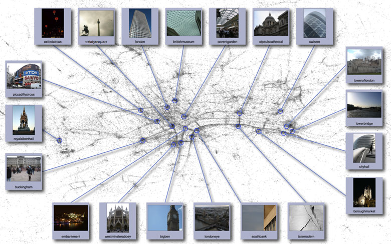 These days, when you take a photo, your camera will save all sorts of useful information inside the photo. GPS-enabled cameras -- even the iPhone -- are even equipped to save the location where the shot was taken. Working at Cornell, research David Crandall and a team collected this locational information from 35 million flickr photos. (Most of these photos were copyrighted, but we are assuming that the geographic information inside the photo is fair use.) They then plotted the locations -- and this is what they found. The maps appeared. Above is the London version, striking for the outline of the Thames and its bridges. But on the team's photomap page you can see they have generated maps of 5 continents/countries and 8 cities, and all are pretty interesting. They're very reminiscent of the "Earth at Night" which we enjoyed so much, except that we're not seeing light, we're seeing attention! They've also located the most-photographed places, reminding us all that if we take a holiday pic of the London Eye or Trafalgar, we are amongst millions doing so. |

|

|
|
04-28-2009, 11:14 AM
|
#2 |
|
Join Date: Jul 2003
Location: Arlington, VA
Posts: 27,717
|
That's really a neat idea. It makes sense that more pictures will be taken where people live, so it shows cities clearly, but it also shows national parks clearly too. Nobody lives in Yosemite, but it shows up like a city. Same with the Grand Canyon.
|
|
|
|
|
04-28-2009, 01:01 PM
|
#3 |
|
UNDER CONDITIONAL MITIGATION
Join Date: Mar 2004
Location: Austin, TX
Posts: 20,012
|
I remember a little side bit in one of the Baroque Cycle books by Neal Stephenson, about how with enough data you can pull relevant patterns out of anything. His example was if you somehow had a list of flat-steps (along a sidewalk) versus up- or down-steps (on or off a curb) taken from everyone who walked all over the city, you could eventually create a completely accurate and usable map of that city's streets, even though the individual data paths never accounted for who turned where on what length of walk.
|
|
|
|
|
04-28-2009, 01:54 PM
|
#4 |
|
Guest
Posts: n/a
|
That's incredibly cool. I know a lot of people are bothered by how technologies are changing how we relate to the world, but I love it.
|
|
|
|
04-28-2009, 05:33 PM
|
#5 |
|
Junior Master Dwellar
Join Date: Sep 2007
Location: Northern California
Posts: 2,122
|
The map for the US brings to mind an IOTD from last November, which also provided a sort of unexpected map: from roads.
http://cellar.org/iotd.php?threadid=18784 |
|
|
|
|
04-29-2009, 09:24 AM
|
#6 |
|
polaroid of perfection
Join Date: Sep 2005
Location: West Yorkshire
Posts: 24,185
|
I love it! You can see the parks on it too (well, I can, because I know where they are).
Also, the strip down the centre of the Thames shows the tourist boat trips that ply their trade. Brilliant. Yes DJ, I thought of that map too.
__________________
Life's hard you know, so strike a pose on a Cadillac |
|
|
|
|
| Currently Active Users Viewing This Thread: 1 (0 members and 1 guests) | |
|
|


 Linear Mode

