
|
|
|||||||
| Image of the Day Images that will blow your mind - every day. [Blog] [RSS] [XML] |
 |
|
|
Thread Tools | Rate Thread | Display Modes |
 11-22-2008, 11:08 PM
|
#1 | |
|
The future is unwritten
Join Date: Oct 2002
Posts: 71,105
|
November 23, 2008: Roads
Roads, streets, highways, thoroughfares, lanes, etc, of the USA.
Well 48 states of it, anyway. Quote:
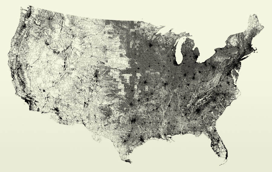 That's it, just roads. I wonder how much heat is retained by all that pavement? I wonder how many reptiles get squashed basking in that warmth? I now know why the chicken crossed the road, however, it had no choice. LINK
__________________
The descent of man ~ Nixon, Friedman, Reagan, Trump. |
|

|

|
|
11-23-2008, 12:07 AM
|
#2 |
|
Alphabetarian
Join Date: Oct 2008
Posts: 12
|
Neato... Mmm...squashed reptiles, my fave. So should we be renaming this to something like the "Highest Likelihood of Finding Yummy Roadkill Map"?

|
|
|
|
|
11-23-2008, 03:43 AM
|
#3 |
|
Doctor Wtf
Join Date: Oct 2007
Location: Badelaide, Baustralia
Posts: 12,861
|
I'd like to see the same done with railroads, and regular airline routes. I fear it would be very depressing in terms of inefficient transport.
__________________
Shut up and hug. MoreThanPretty, Nov 5, 2008. Just because I'm nominally polite, does not make me a pussy. Sundae Girl. |
|
|
|
|
11-23-2008, 06:40 AM
|
#4 |
|
The future is unwritten
Join Date: Oct 2002
Posts: 71,105
|
I think you're missing the point. The same thing done with railroads and/or air routes wouldn't show anything but patterns without reference. They could be in Africa or Asia or on the Moon.
__________________
The descent of man ~ Nixon, Friedman, Reagan, Trump. |
|
|
|
|
11-23-2008, 06:51 AM
|
#5 |
|
Doctor Wtf
Join Date: Oct 2007
Location: Badelaide, Baustralia
Posts: 12,861
|
That was exactly the (well, my) point. Lots and lots of roads, very few railways.
__________________
Shut up and hug. MoreThanPretty, Nov 5, 2008. Just because I'm nominally polite, does not make me a pussy. Sundae Girl. |
|
|
|
|
11-23-2008, 07:09 AM
|
#6 |
|
The future is unwritten
Join Date: Oct 2002
Posts: 71,105
|
You do realize this image shows nothing but roads, right? Other than I told you, how do you know this is the USA? Because the pattern of roads show the outline, the boundaries and physical features like large lakes and mountainous regions. Rail and air routes would not show you that. There would be no reference.
__________________
The descent of man ~ Nixon, Friedman, Reagan, Trump. |
|
|
|
|
11-23-2008, 08:07 AM
|
#7 | |
|
Superior Inhabitant
Join Date: Jan 2002
Location: Calgary, Alberta, Canada
Posts: 71
|
Quote:
Now of course it wouldn't precisely match the US' political outline in the same striking manner as the road map above does. But I'd be rather surprised if some distorted phantom of the familiar american outline didn't appear, if for no other reason than because of all the large cities that dot the eastern and western coastlines. I, too, would be interested in seeing such maps. If only to see how great the distortion was. |
|
|
|
|
|
11-23-2008, 08:53 AM
|
#8 | |
|
The Un-Tuckian
Join Date: Apr 2007
Location: South Central...KY that is
Posts: 39,517
|
Quote:

__________________
 These statements have not been evaluated by the FDA, EPA, FBI, DEA, CDC, or FDIC. These statements are not intended to diagnose, cause, treat, cure, or prevent any disease. If you feel you have been harmed/offended by, or, disagree with any of the above statements or images, please feel free to fuck right off. |
|
|
|
|
|
11-23-2008, 05:51 PM
|
#9 |
|
Cleverly disguised as a responsible adult
Join Date: Jan 2001
Location: Dallas, TX
Posts: 3,338
|
Looks like a track of my movements over the last few years...
__________________
Never be afraid to tell the world who you are. -- Anonymous |
|
|
|
|
11-23-2008, 05:55 PM
|
#10 | |
|
The future is unwritten
Join Date: Oct 2002
Posts: 71,105
|
Quote:
__________________
The descent of man ~ Nixon, Friedman, Reagan, Trump. |
|
|
|
|
|
11-23-2008, 08:32 PM
|
#11 |
|
Hypocrisy: prejudice with a halo
Join Date: Mar 2007
Location: Savannah, Georgia
Posts: 21,393
|
Very cool.
__________________
Anyone but the this most fuked up President in History in 2012! |
|
|
|
|
11-23-2008, 08:41 PM
|
#12 | |
|
Operations Operative
Join Date: Apr 2008
Posts: 479
|
Quote:
|
|
|
|
|
|
11-23-2008, 08:51 PM
|
#13 | ||
|
lives inside a Mobius strip
Join Date: Dec 2007
Posts: 1,120
|
Quote:
Quote:

__________________
I knew I shoulda taken that left turn at Albuquerque! - Bugs Bunny |
||
|
|
|
|
11-23-2008, 09:27 PM
|
#14 | |
|
barely disguised asshole, keeper of all that is holy.
Join Date: Nov 2007
Posts: 23,401
|
Quote:
__________________
"like strapping a pillow on a bull in a china shop" Bullitt |
|
|
|
|
|
11-23-2008, 09:54 PM
|
#15 |
|
Kinda New Member
Join Date: Nov 2008
Posts: 1
|
for airlines http://au.youtube.com/watch?v=ewrOyeTjoiI is probably what you are looking for, and you can see the outline of the US there. I havn't seen anything like that for railroads though.
|
|
|
|
|
| Currently Active Users Viewing This Thread: 1 (0 members and 1 guests) | |
|
|


 Linear Mode

