
|
|
|||||||
| Image of the Day Images that will blow your mind - every day. [Blog] [RSS] [XML] |
 |
|
|
Thread Tools | Rate Thread | Display Modes |
 03-09-2016, 10:32 PM
|
#1 |
|
The future is unwritten
Join Date: Oct 2002
Posts: 71,105
|
Mar 10th, 2016: Night Fires
I love lightning, but in most storms it’s wham bam thank you ma’am, and you’re instantly in reminisce mode, hoping for a second date.
Barring an attack at Grover’s Mill, or Chicken Little was right, nothing is as scary and at the same time beautiful, as a forest fire at night. 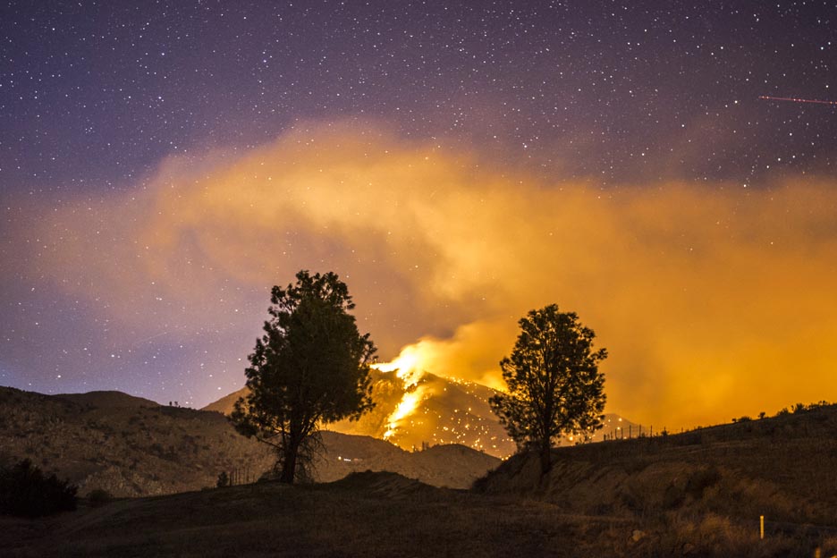 There's a bunch of pro photographers who will drop most anything to race to a new fire, two of whom are Jeff Frost and Stewart Palley. Terrain and fire favorable conditions seem to give California a lot of spectacular fires. Wind from the ocean, or from the desert, seems to drive these fires so fast individual trees appear to explode like a row of “match heads”. 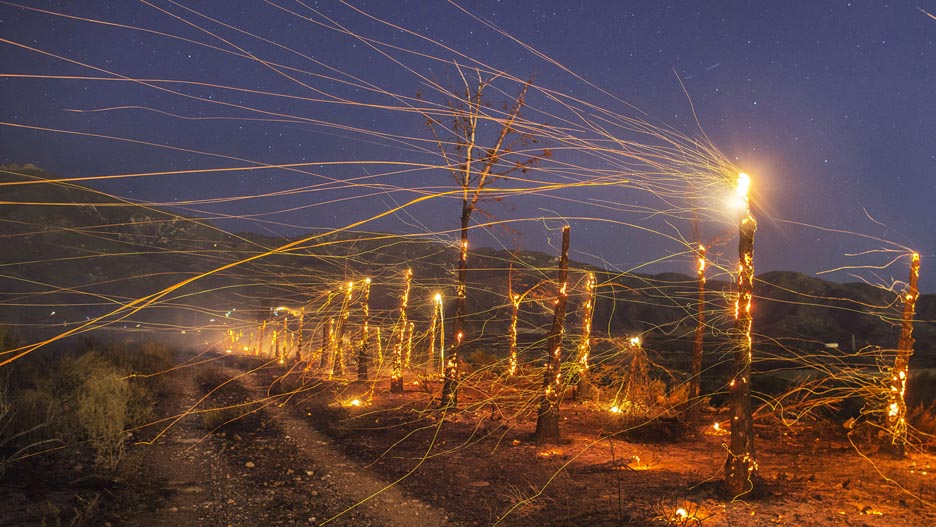 But even after the fire front races through exploding those “match heads”, the “match” in the form of the trunk continues to burn, with the wind carrying embers sometimes for miles. Don’t be like firemen, run AWAY from fire... unless you're in school, in which case you must walk, don't run, or it will go on your permanent record.
__________________
The descent of man ~ Nixon, Friedman, Reagan, Trump. |

|

|
|
03-10-2016, 07:47 AM
|
#2 |
|
Banned
Join Date: May 2015
Posts: 660
|
I may have to come back to this one if we get a bad fire season here. More than once I've been able to watch a fire march across one of the Bitterroot or Sapphire Mountains--B'root is scarier because those mountains are not just bigger but much MUCH closer. Maybe I'll email those dudes if a fire I can see from my balcony flares up this summer. We do have a couple of motels in town, and if such a fire is in the big mountains it could be incredibly spectacular.
Montana isn't the safest place to live--bears, drunks, antisocial freaks with guns (I'm an antisocial freak, but a gunless one as I believe I've no business carrying something like that since I have a very poor understanding of their workings and my nerves are way too twitchy), mountainous back-country in the west and water-poor, shelterless rolling plains in the east, but it's fire season that truly scares me. Sometimes it's sparked by lightning, sometimes by idiots, and one dude is probably still in jail for setting like 9 fires in 2005-2007ish so he could get smokejumper work. Hell, every Bitterroot Mountain peak I can see from home still has scars from the infamous epic burn-down of Y2K (for which I did not live here). The neighbor I take care of was living in a travel trailer parked in a field upside the highway and river less than 10 miles south of where we live now, and bailed when the fires came down to the opposite riverbank just a football field (US, not everyone else's football) or so away from his front door. They say something like 30% of the mountainous land bordering this valley was on fire that summer, and from the vast swathes of dead trees up every mountainside I'm inclined to believe them. And of course, there's THE photo. https://upload.wikimedia.org/wikiped...e_high_res.jpg Even has its own Snopes page due to frequent mis-attribution, and it was taken right around about EXACTLY where I like to bird-watch and rockhound at Sula, which for most tourists consists of the bridge mentioned on the Snopes page and the campground/store/gas station upside Hwy 93 at the south end of said bridge. South of Sula, you can either go south into Idaho immediately or go west and be in Idaho very soon; Chief Joseph Pass is in that area and straddles the Continental Divide. There was also the Mustang Complex mess a few years ago: http://tinyurl.com/huobole The western border of Montana looks vaguely like a human profile, and the squiggly line in that image is the Idaho-Montana border. The point where it stops going east and turns back south, near the bottom of the image, is less than an hour from my front door. Where the arrows say "smoke in valley" is the path of the Clark Fork, which I-90 crosses like 5 times between Lookout Pass and Missoula; it's one of our "almost home" landmarks the first time we see the little green sign that just says Clark Fork River when we're inbound from our annual Gallivant Westward to Oregon to visit families. The big thick pale north-south streak on the right, inside the "nose" part of the border, is where I live. It was like Beijing around here for about a month solid, and the horrible air quality damaged a lot of people. One of my former downstairs neighbors, an elderly veteran, died of the pneumonia it gave him. Mr. Frost, Mr. Palley, I may just be in touch...and if Montana is too far away, Utah is highly flammable too. |
|
|
|
|
03-10-2016, 01:30 PM
|
#3 | |
|
The Un-Tuckian
Join Date: Apr 2007
Location: South Central...KY that is
Posts: 39,517
|
Quote:

__________________
 These statements have not been evaluated by the FDA, EPA, FBI, DEA, CDC, or FDIC. These statements are not intended to diagnose, cause, treat, cure, or prevent any disease. If you feel you have been harmed/offended by, or, disagree with any of the above statements or images, please feel free to fuck right off. |
|
|
|
|
|
| Currently Active Users Viewing This Thread: 1 (0 members and 1 guests) | |
|
|


 Linear Mode

