The Cellar  

Go Back   The Cellar > Images > Image of the Day
FAQ Community Calendar Today's Posts Search

Image of the Day Images that will blow your mind - every day. [Blog] [RSS] [XML]


Thread Tools Rate Thread Display Modes
Prev Previous Post   Next Post Next
Old 03-12-2010, 11:26 PM   #1
xoxoxoBruce
The future is unwritten
 
Join Date: Oct 2002
Posts: 71,105
Mar 13, 2010: Inuit Map

Inuit Wood Map, to be more precise, from Kalaallit Nunaat... that's Greenland to most of us.


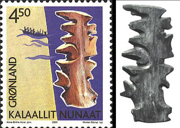
Not exactly a AAA TripTik, and a far cry from Google maps, although still a cut above MapQuest.
It doesn't look very detailed, does it, well, there's a reason for that...
Quote:
These Inuit charts were usually carved from driftwood and are made to be felt rather than looked at. The Inuit hold this map under their mittens and feel the contours with their fingers to discern patterns in the coastline. The land is very abstract. It is limited to “edges” that can be felt on a dark night in a kayak. Since they are made of wood they are impervious to the weather, and will float if they are dropped overboard accidentally. It will also last longer that one that is printed.
See, practical, functional, and close enough in detail.

link
__________________
The descent of man ~ Nixon, Friedman, Reagan, Trump.
xoxoxoBruce is offline   Reply With Quote


Currently Active Users Viewing This Thread: 1 (0 members and 1 guests)
 

Posting Rules
You may not post new threads
You may not post replies
You may not post attachments
You may not edit your posts

BB code is On
Smilies are On
[IMG] code is On
HTML code is Off

Forum Jump

All times are GMT -5. The time now is 09:24 PM.


Powered by: vBulletin Version 3.8.1
Copyright ©2000 - 2024, Jelsoft Enterprises Ltd.