It's the IotD's first animated image.
This has been widely seen on the net since yesterday, and probably half of you all have already seen it. It's here for the folks who haven't.
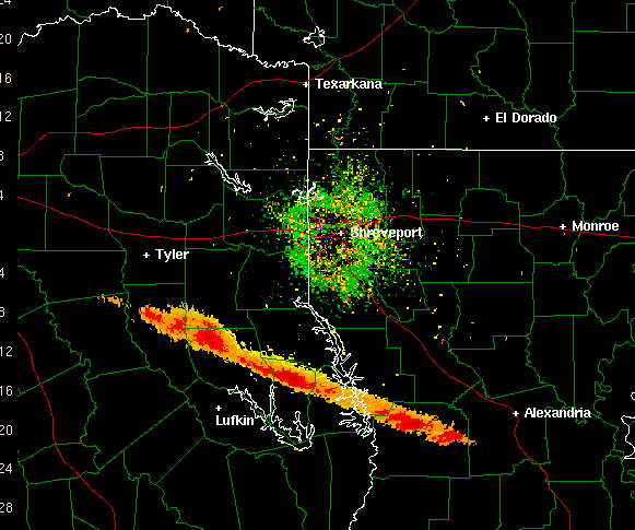
If the radar shows the equivalent of the strongest storm on record, why did 99.9999% of the people on the ground feel nothing? Turns out the whole system is set up to watch for water and water vapor, and the debris of the shuttle body is much more reflective to radar.
(The green speckles around the center are haze, and you can ignore them.)
Pity: any time code information is missing, so we don't know what time period is covered here. But the numbers on the left are miles, telling us that to the "eye" of the weather radar, the plume and debris was about three miles wide, about twenty miles long, and lasted for quite a while.
Stupidity: Philly local news teased video of this animation with the line "See what the disaster looked like from outer space!" Like most local news teases, that statement is blatantly wrong. The image is shown from the perspective of above, as if you might be seeing something from space; but this is what it looked like from radar equipment on the
ground. From space, it wouldn't look anything like this.
It's easy to see how casual errors like this are introduced into the local news: a newsroom flunkie producer watched the video and wrote something off the top of his/her head. It's probably not that the science education is lacking enough that the copy writer wouldn't know the difference; it's just that getting the copy accurate is not a high priority. A higher priority is writing exciting copy that will keep the viewers around through the commercial break.