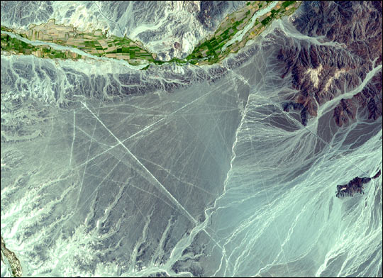
An extraordinarily clear satellite image of Peru's Nasca lines, from the Earth Science Pic of the Day. Their caption:
The above image shows a portion of the geometric forms that compose the Nasca Lines of Peru. It was taken on December 22, 2000 from the Advanced Spaceborne Thermal Emission and Reflection Radiometer (ASTER), an instrument aboard NASA?s Terra satellite. For this image, both visible and infrared spectral bands were combined to create a simulated true-color image.
The Nasca Lines were made over 1,000 years ago by native people who lived in what is today Peru - not by extraterrestrials as suggested by some people. The Lines are located in the Pampa region of Peru, a remote desert plain near the Peruvian coast, about 400 km south of Lima. They were initially spotted when commercial airlines began flying across Peru in the 1920s. Passengers reported seeing what looked like primitive landing strips on the ground below. It was discovered later that the Lines are furrows, made by removing iron-oxide coated pebbles covering the surface of the desert. When the gravel is removed, the contrast with the lighter colors beneath can be striking. The exact purpose of the Lines is not known. Most are likely works of art but, as postulated by some archeologists, some of the Lines may mark the past location of underground sources of water.