
|
|
|
What's IotD? The interesting, amazing, or mind-boggling images of our days. |
|
IotD Stuff |
|
Permalink Latest Image |
|
|
|
Some folks who have noticed IotD
Neatorama |
|
Common image haunts
Astro Pic of the Day |
|
Advertising |
5/11/2003: Shenandoah topography
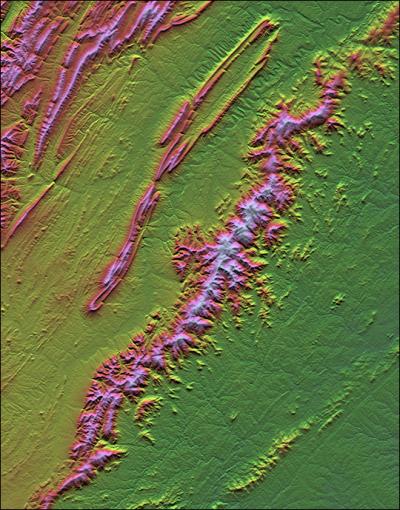
The Earth Sci pic of the day yields this nice one of Virginia's Shenandoah national park by Shuttle Radar Topography Mission data.
Now here's the odd part: no camera was used to create this image.
They recorded the various elevations in detail, via radar on the shuttle. Then they created this image from that data: one pass to create the shading (which areas are light and which dark) and one to create the color (different heights of the land get different colors).
xoxoxoBruce Sunday May 11 02:20 PM
I can see how they can assign colors to elevations but I don't understand the shading part.
Undertoad Sunday May 11 02:34 PM
I think they go North to South, and when there is drop in elevation they add darkness (with more darkness for a larger drop) so you get a shadowing effect. Or something.
wolf Sunday May 11 05:54 PM
I'd love to see images like this next to a topographic map of the same area ... I'm guessing that between that pink ridgy thing and the pink hilly thing is a river ... and those squiggles up toward the top also look like a watercourse. (of course it could be a highway of extreme width and constant declination from the landsurface, but ...
NEAT stuff UT!
xoxoxoBruce Sunday May 11 08:01 PM
About 20% of the way down the mountain ridge on the right it cleaves. I think that's the junction of the Skyline Drive and Blueridge Parkway. I remember one summer night at a scenic pulloff near there, on the hood of a black Thunderbird, with a full moon.....
Griff Sunday May 11 08:22 PM
one sentance story?
with a full moon to guide him Gen. Thomas "Stonewall" Jackson once again repulsed the Yankee invader.
|
Your reply here?
The Cellar Image of the Day is just a section of a larger web community: a bunch of interesting folks talking about everything. Add your two cents to IotD by joining the Cellar. |