
|
|
|
What's IotD? The interesting, amazing, or mind-boggling images of our days. |
|
IotD Stuff |
|
Permalink Latest Image |
|
|
|
Some folks who have noticed IotD
Neatorama |
|
Common image haunts
Astro Pic of the Day |
|
Advertising |
3/6/2006: Graphic of freight in and out of California

axlrosen finds this really cool item at the US Department of Transportation: a map of international and domestic freight, as it flows in and out of California destinations by truck.
It's IotD'd because it's an awesome graphic display of quantitative information, a way to communicate a great deal using an imaginative graphic. And there are tons of other maps at the site, all very cool and very interesting. (For instance, most domestic freight shipped by sea in or out of Philadelphia goes to... Pittsburgh?!? What? How?)
barefoot serpent Monday Mar 6 02:32 PM
Reminds me of the graphic representation of Napoleon's march to Moscow
http://www.edwardtufte.com/tufte/minard
made famous in Edward Tufte's The Display of Quantitative information.
edit: The Visual Display of Quantitative Information
Pancake Man Monday Mar 6 03:16 PM
Lesson learned here? Don't make fun of truckers in California.
WabUfvot5 Monday Mar 6 05:16 PM
We control the cocaine flow and the hashish flow.
Cyclefrance Monday Mar 6 05:26 PM
It's OK, but how do you work out what is coming in and what is going out?
Elspode Monday Mar 6 05:28 PM
Looking at this graphic only reinforces the notion that the Midwest, especially Kansas City, is just the part you have to drive through to get somewhere else. Jeez, even Des Moines gets more traffic through it on I-80 than we do on I-70.
barefoot serpent Monday Mar 6 05:53 PM
|
Originally Posted by Elspode
more traffic through it on I-80 than we do on I-70.
|
Undertoad Monday Mar 6 06:02 PM
Yabbut Spode, this is just the California traffic.
Here's the Florida map:
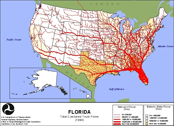
Undertoad Monday Mar 6 06:07 PM
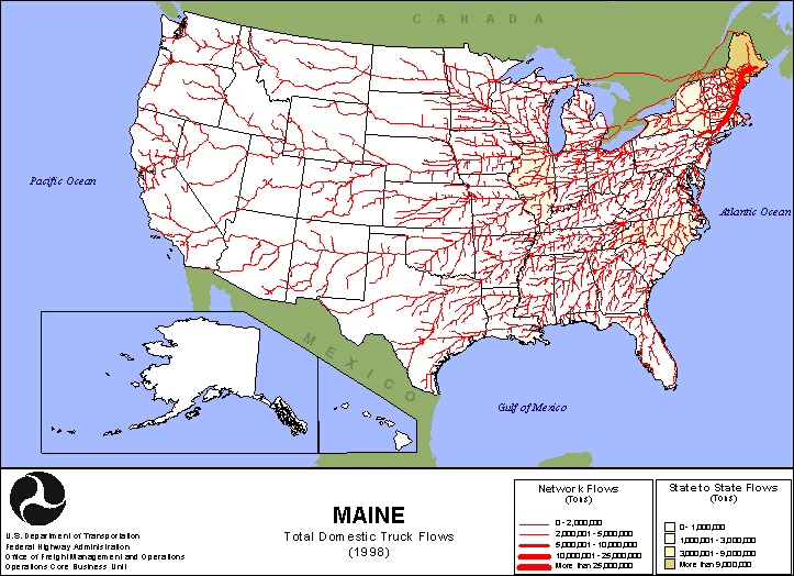
Maine domestic is kinda cool because, according to the data, 3/4ths of it is logs. So the bulk of ME output is heavy and doesn't go very far, just far enough to be milled. But other ME products, such as lobsters, might trickle across the country:
Katkeeper Monday Mar 6 06:20 PM
Lobsters might be flown, not trucked. Poland Spring Water would be one item. And how about L.L. Bean??
barefoot serpent Monday Mar 6 07:15 PM
looks like they're counting the St. Lawrence Seaway traffic -- containers, barges, ferrys?
Elspode Monday Mar 6 08:04 PM
UT is right...and on further consideration, let Des Moines have all them flakey Left Coasters! 
xoxoxoBruce Monday Mar 6 09:36 PM
|
Originally Posted by barefoot serpent
looks like they're counting the St. Lawrence Seaway traffic -- containers, barges, ferrys?
|

glatt Monday Mar 6 10:06 PM
Maine also has potatoes and blueberries.
xant Tuesday Mar 7 12:07 AM
So, I looked at a bunch of those maps picked arbitrarily, and there's thick red lines coming out of every state. None appear to be up to California's shipping level.
The one that gave my home state the best run for its money? That would be Texas. It is then that one realizes why there's so much shipping done for these two states, and for Florida. It's not because the midwest and southwest US are "flyover states", but because of maritime shipping. You've probably heard the phrase "Made in China"? Well, those trinkets have to stop in California first. Should be no surprise that results in a lot of truck shipping.
CharlieG Tuesday Mar 7 08:49 AM
How about NY State

Or JUST New York City

xoxoxoBruce Tuesday Mar 7 06:52 PM
I wonder what all these maps would look like if you subtracted all the walmart crap? 
capnhowdy Tuesday Mar 7 07:47 PM
|
Originally Posted by xoxoxoBruce
I wonder what all these maps would look like if you subtracted all the walmart crap?
|
It would prolly go from shipping veins to capillaries.

BrianR Tuesday Mar 7 11:13 PM
Looks familiar to me. I've hit most of those routes at one time or another already!
tw Wednesday Mar 8 01:06 AM
I was rather surprised how little is still shipped in containers by rail. I was also surprised how much freight that arrives in the NE by ship ends up on the Gulf Coast by truck.
tw Thursday Mar 9 03:15 AM
In social studies, we were taught that the St Lawrence Seaway provided mid-west ports with access to the internation commerce. However the figure confirms what I have heard so often elsewhere. The St Lawrence Seaway was constructed too small to be sufficiently competitive:
milkfish Friday Mar 10 06:24 AM
|
Originally Posted by Undertoad Here's the Florida map: |
xoxoxoBruce Friday Mar 10 07:48 PM
The flow is going the right way, it's the state that's limp. 
busterb Friday Mar 10 08:04 PM
Years ago, when they used ice pack chickens, Hwy 80 was wet all time from the water drippin off chicken trucks from MS. headed to CA. Then they went to co2 pack. BrianR. Have you been around long enought to remember blowing ice on load and cranking the put-put? BTW they don't pay freight on ice.
pdaoust Sunday Mar 12 08:03 PM
The first thing I thought of when I saw the map was, "oh my gosh, the red Martian scourge is real. Good thing it hasn't spread up here to Canada."
|
Your reply here?
The Cellar Image of the Day is just a section of a larger web community: a bunch of interesting folks talking about everything. Add your two cents to IotD by joining the Cellar. |